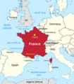
File:France and its region.png
Appearance

Size of this preview: 524 × 600 pixels. Other resolutions: 210 × 240 pixels | 419 × 480 pixels | 794 × 909 pixels.
Original file (794 × 909 pixels, file size: 326 KB, MIME type: image/png)
File history
Click on a date/time to view the file as it appeared at that time.
| Date/Time | Thumbnail | Dimensions | User | Comment | |
|---|---|---|---|---|---|
| current | 02:50, 11 April 2024 |  | 794 × 909 (326 KB) | Thinker78 | added locations, improved format |
| 02:33, 5 September 2023 |  | 712 × 831 (231 KB) | Thinker78 | Added places names (Corsica, Sardinia, Gulf of Lion, Catalonia) | |
| 07:36, 13 May 2023 |  | 650 × 805 (197 KB) | Thinker78 | Uploaded a work by Thinker78, TUBS from File:France in European Union (-rivers -mini map).svg with UploadWizard |
File usage
The following 3 pages use this file:
Global file usage
The following other wikis use this file:
- Usage on blk.wikipedia.org
- Usage on bn.wikipedia.org
- Usage on iba.wikipedia.org
- Usage on incubator.wikimedia.org
- Usage on tl.wikipedia.org

